Applied Mathematics, Computational Modelling

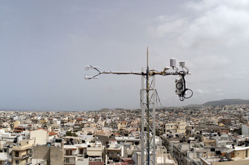
Flux Towers for the direct measurement of heat and carbon dioxide (CO2) emissions installed in Heraklion by FORTH, towards making the city a reference point for the future CO2 emission monitoring system of the European Commission.
The research is carried out by the Remote Sensing Laboratory of FORTH (http://rslab.gr), operating the Flux Towers and processing the valuable data extracted. The first Tower has been deployed in the center of Heraklion for five years. Recently, a second one, highly equipped, was deployed in the residential area of Mastaba, to provide data for a more objective assessment of the city's emissions. By analyzing satellite and drones observations, the Lab has created a detailed, 3D city model, making possible the identification of the source areas of the CO2 and heat emissions within a large radius around each Tower, by means of the Eddy Covariance approach (http://rslab.gr/heraklion_eddy.html).
Also, in the framework of the cooperation between the RSLab and the AERONET Network (Aerosol Robotic Network) of NASA, a sun-photometer was recently installed in the center of Heraklion, for measuring aerosols optical thickness, which is related to particulate matter, an important indicator of air quality (https://aeronet.gsfc.nasa.gov/cgi-bin/data_display_aod_v3?site=FORTH_RSLab&nachal=2&level=1).
It is worth noting that the Lab participates in an international research team which recently conducted a study in 11 European cities, showing a clear reduction in CO2 emissions during the first lock down due to COVID-19, which exceeded 70% in Heraklion. This study, which was published in a high-level science review, has also quantified the gradual increase in emissions to previous years' levels, following the lifting of restrictive measures.
The above equipment provides observations that are used for research at local and pan-European level. They help to better understand the interaction between cities and climate change (urbisphere project), urban resilience issues (CURE project), and to develop a platform for the operational recording and monitoring of anthropogenic CO2 emissions at European level (CoCO2 project), which is expected to join the CO2M satellite mission scheduled by the European Space Agency (ESA). Also, these measurements are utilized by the Municipality of Heraklion in the framework of a Program Agreement with FORTH, for the monitoring of CO2 emissions in the city.
The Remote Sensing Lab of the Institute of Applied and Computational Mathematics of FORTH, is properly equipped and staffed to support the monitoring and recording of emissions in the framework of the Covenant of Mayors for Climate and Energy. It also assists in civil protection actions to address thermal comfort and global warming effects on health, towards environmental management to improve the urban microclimate and reduce energy consumption, urban planning for energy efficiency upgrades, bioclimatic regeneration, specifications for urban expansions, as well as, bioclimatic documentation of urban regeneration studies.
Further information: Dr. Nektarios Chrysoulakis, email: zedd2@iacm.forth.gr
Remote Sensing Laboratory (http://rslab.gr)
urbisphereproject (http://urbisphere.eu) funded by the European Research Council (ERC)
CURE project (http://cure-copernicus.eu) and CoCO2 project (https://coco2-project.eu) funded by Horizon 2020


