
Announcements
Satellite image change detection for rapid detection of landslides after a devastating rainstorm event-“Oceanis” in Crete, Greece
The IMS-FORTH Geophysical Satellite Remote Sensing and Archaeo-Environment Laboratory (Greece), in collaboration with the Centre for Applied Geosciences at the University of Portsmouth (UK), has made a rapid preliminary assessment of recent flooding and landslide devastation in western Crete, which took place after an unprecedented heavy rain storm-“Oceanis” during 24-26 February, 2019. Based on rainfall data from the National Observatory of Athens only in the eastern region of the White Mountains, an area of about 140 square kilometers, more than 80 million cubic meters of water fell. The costs of damage due to the devastating weather in Western Crete is assessed by the Region of Crete at over of 130 million euros.
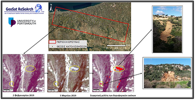
Planetscope satellite imagery, which can provide daily views of the Earth with a relatively detailed spatial resolution (3.5m pixels), was used before and after the period of heavy rainfall, to detect and map the locations of terrain instability (ie, landslide ‘scars’ in the vegetation cover, debris flows and associated areas of erosion or deposition). The ongoing research revealed a number of small and large-scale landslides recorded using the satellite remote sensing in the south of Rethymno city, such as Roussospiti, Mikra Anogia, Xeron Village and the wider neighboring villages. The intense rainfall during the past weeks in conjunction with the relatively soft sedimentary formations that characterize the area, contributed to the saturation of the soil and triggering the phenomenon of terrain instability. The first outcomes are indicative of the reliability of the methodological framework, which is reinforced by the ground-truth confirmation of numerous landslides.
Examples of the output from this terrain instability detection methodology before and after the intense rainfall are shown below, for an area of Crete extending from the city of Rethymno, southwards to Roussospiti. At all of the locations displayed here, the change analysis of the temporal satellite imagery had a greater than 95% variation in clustered pixels between the two satellite images.
A team led by Dr Nasos Argyriou of the Geophysical-Remote Sensing and Archaeo-Environment Laboratory will be carrying out further analysis of satellite imagery, in conjunction with Dr Richard Teeuw at the University of Portsmouth, to assess the causes of the flooding and terrain instability phenomena observed during this severe rain storm event- “Oceanis”, aiming to produce guidelines for improved disaster risk reduction.
This case study illustrates the potential of new satellite remote sensing technologies for the rapid and detailed mapping of geohazards that accompany severe storms, with large enough areas covered. Such information for the terrain instability outputs can be of use to decision makers during the response and recovery stages of emergency management.
Planetscope imagery for the Rethymno-Roussospiti region (top), underlain by a detailed sub-scene of imagery from before and after the severe rainfall of 24-26 February 2019, in which pixels with >95% change are shown in red; with in-situ photographs of the two main terrain instability features (right).